
What Is The Most Popular Maritime Traffic Data API?
Are you a developer looking for the most popular maritime traffic data API? If so, you’ve come to the right place. In this article, we’ll explain what an API is, why you should use a maritime traffic data API, and what the most popular maritime traffic data APIs are.
Maritime traffic encompasses all those operations involving the transport of goods by sea or inland waterway. Two-thirds of the earth’s surface is covered by water, and since ancient civilizations, humans have used maritime transport to trade around the world. Today, 80% of international trade is carried out by sea: it is the most cost-effective, safe, and efficient way of transporting large quantities of goods from one part of the world to another.

APIs and communications
How do people communicate with one another? Right, people can communicate their needs, wants, and ideas through gestures, facial expressions, and verbal and written language. At the same time, user interface (UI) components—a screen with a menu and graphical elements, a keyboard, and a mouse—are necessary for our interaction with computers, apps, and websites.
On the other hand, software or its components don’t require a graphical user interface to communicate with one another. Programs employ machine-readable interfaces, or APIs, to exchange information and functionalities.
You’ve probably encountered the acronym API if you’ve ever read tech blogs or publications. What does it stand for, even though it seems solid? Application Programming Interface is referred to as API.
why you should use a maritime traffic data API?
Maritime traffic data APIs provide real-time information on the movement of vessels in a given area. This information can be used to monitor vessel activity and identify potential hazards. It can also be used to track vessels and goods in transit and ensure that they are delivered safely and on time. Additionally, maritime traffic data APIs can be used to optimize shipping routes and reduce fuel costs.
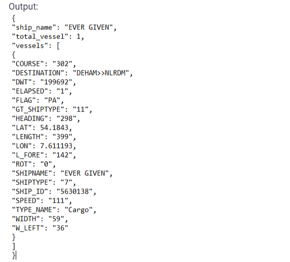
The most popular maritime traffic data APIs: Vessel Trafic Information
This API provides live information about vessels around the globe. Check your tracking shipments with this API and receive additional information about the ship in question. It receives parameters like ship number, latitude, and longitude and you will get a list of all the vessels that are located in that area.
To make use of it, you must first:
1- Go to Vessel Traffic Information API and simply click on the button “Subscribe for free” to start using the API.
2- After signing up in Zyla API Hub, you’ll be given your API key. Using this one-of-a-kind combination of numbers and letters, you’ll be able to use, connect, and manage APIs!
3- Employ the different API endpoints depending on what you are looking for.
4- Once you meet your needed endpoint, make the API call by pressing the button “run” and see the results on your screen.