3 Common Vessel Data API Use Cases
Tankers are used to transport oil and other liquids across the ocean. These ships can carry millions of gallons of fuel, making them a target for terrorists and pirates. By tracking tanker movements, you can help keep the world’s oceans safe.
In this article, we will explain how an API helps track these tankers and other common use cases for such an API.
The tanker ship is a type of ship used to transport liquids such as oil, chemicals, and water. Tankers are typically large in size and often have multiple decks. These ships are typically used for long-distance transportation due to their large size and ability to carry large amounts of liquid.
The size of the ship depends on the amount of liquid that it can carry. Tankers are usually larger than other types of ships because they must be able to hold large quantities of liquid. Tankers are typically used for long-distance transportation due to their large size and ability to carry large amounts of liquid.

So, 3 Common Vessel Data API Use Cases:
1- Tankers Tracking
There are many ways to track tankers, whether you want to track them by satellite or by more traditional methods like radar or sonar.
One way you can track tankers is by using satellite imagery. This is done by taking high-resolution images of the ocean and analyzing them for signs of tankers.
Another way you can track tankers is by using radar or sonar. Radar is a type of technology that uses radio waves to detect objects in the environment.
Sonar is a similar technology that uses sound waves instead of radio waves. Both of these technologies can be used to detect tankers in the ocean and track their movement
2- Ship Tracking
Ship tracking is the process of tracking the location and movement of ships at sea. This can be done in a number of ways, including using satellites, radar, and GPS systems.
There are many uses for ship tracking, including tracking the location of valuable cargo, monitoring environmental conditions at sea, and monitoring the movement of marine life.
Ship tracking systems are becoming increasingly common on board ships, allowing ship owners and operators to monitor their vessels in real-time from anywhere in the world.
These systems allow ship owners and operators to monitor their vessels in real-time from anywhere in the world. They also allow them to collect data on vessel performance and efficiency, which can be used to improve future operations.
3- Vessel Traffic Information Database
Build your own marine traffic information base with an API.
For all this, we recommend our favorite;
Vessel Traffic Information API
This API offers real-time data on ships all over the world. Use this API to check your shipment tracking and get more details about the particular ship.
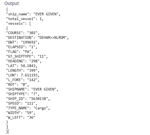
This API will receive parameters like ship number, latitude, and longitude and you will get a list of all the vessels that are located in that area. Get information like destination port, departure port, information about the ship, its max draught, how long it is, and more. See an example of this API response:
To make use of it, you must first:
1- Go to Vessel Traffic Information API and simply click on the button “Subscribe for free” to start using the API.
2- After signing up in Zyla API Hub, you’ll be given your personal API key. Using this one-of-a-kind combination of numbers and letters, you’ll be able to use, connect, and manage APIs!
3- Employ the different API endpoints depending on what you are looking for.
4- Once you meet your needed endpoint, make the API call by pressing the button “run” and see the results on your screen.